ABS ASGS 2026 Main Structure Product Guide
Disclaimer
Overview
The Main Structure and Greater Capital City Statistical Areas is the primary geographic framework within the Australian Statistical Geography Standard (ASGS). It is designed by the Australian Bureau of Statistics (ABS) for the collection, analysis and dissemination of statistical information across Australia.
The structure consists of a nested hierarchy of geographic areas that enable data to be analysed and reported at a range of geographic scales, from small local areas through to large regional and metropolitan areas. ABS Boundaries provides spatial representations of these statistical areas together with the associated identifiers, codes and names required for integration with demographic, economic and social datasets.
Use Cases
The Main Structure and Greater Capital City Statistical Areas data supports a wide range of analytical and operational workflows, including:
Demographic and population analysis
Census data integration
Market and catchment analysis
Service delivery planning
Infrastructure planning
Socioeconomic analysis
Government reporting
Research and policy development
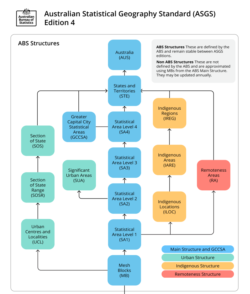
2026 ASGS ABS Structures, extracted from the ABS Geography Website ABS Geography Website
Detailed attribute definitions and relationships are provided in the data dictionary and data model.
Geoscape Australia welcomes your feedback on our products. We also publish regular updates on the development of our products on the Geoscape website ( www.geoscape.com.au ).
Product Version
1.0
Major Version: 1
Minor Version: 0
Product Version Management
Versioning is managed through incrementing when there is a change to the product schema or a significant change in data population, these are described further below:
- A schema change can affect a major or minor increment to the versioning.
Additive changes (changes that won’t break customers’ ability to work with the data) will be incremented with a minor version increment, an example is the addition of a new attribute.
Removal of attributes or changing the structure of the schema will enact a major change to identify that this requires the attention of all customers and partners.
Where a significant geography of Australia either has a new population of data for an attribute or is populated from a much higher quality source a minor increment will be applied to the product version.
Therefore, the major and minor version will not increment with every data update. Published releases will have a name e.g. ‘May 2025’ and will reference a version of the product e.g. ‘1.0’.
Technical Description
ASGS Main Structure Hierarchy
The structure is built from a hierarchy of geographic regions. Each level aggregates the geographic units beneath it, providing a consistent framework for analysing data at different scales.
The Main Structure is the primary geographic framework within the ASGS and consists of Mesh Block and Statistical Area Level 1-4 (SA1-SA4) boundaries. Mesh Blocks are aggregated to create SA1s, SA1s are aggregated to create SA2s and so on. Only population and dwelling count statistics are released by the ABS at the Mesh Block level. The higher in the hierarchy (SA4>SA3>SA2>SA1>Mesh Block), the more statistics can be released due to privacy concerns being alleviated at higher levels.
The Main Structure boundaries are also the foundational building blocks used to create other ASGS Structures such as the Indigenous Structure and the Remoteness Structure, which are both made by aggregating SA1s. Greater Capital City Statistical Areas (GCCSA) are created from SA4s and are also included in the ABS ASGS 2026 Main Structure product as they are released with the Mesh Block and SA1-SA4 boundaries by the ABS.
Mesh Blocks (MB)
Mesh Blocks are the smallest geographic unit within the ASGS and form the foundation of the Statistical Areas Structure.
All higher-level statistical areas are constructed through the aggregation of Mesh Blocks. They are designed to cover the entire Australian landmass without gaps or overlaps and provide the building blocks for statistical reporting and geographic analysis.
Key Attributes
Unique Mesh Block identifier
ABS Mesh Block code
Mesh Block category
State identifier
Area measurements
Relationships to parent statistical areas
Relationship to Other Statistical Areas
Each Mesh Block belongs to a single:
SA1
SA2
SA3
SA4
GCCSA
through the ASGS hierarchy.
Statistical Area Level 1 (SA1)
Statistical Area Level 1 (SA1) regions are the smallest geographic areas for which many ABS statistics are released.
SA1s provide a balance between geographic detail and statistical reliability, making them suitable for localised demographic and socio-economic analysis. Each SA1 is composed of one or more Mesh Blocks.
Key Attributes
SA1 identifier
SA1 code
Relationships to parten statistical areas
State information
Area measurements
Statistical Area Level 2 (SA2)
Statistical Area Level 2 (SA2) regions are designed to represent communities and functional areas that interact together socially and economically.
SA2s are commonly used for the publication and analysis of population, housing and community statistics. Each SA2 is formed through the aggregation of SA1 regions.
Key Attributes
SA2 identifier
SA2 code
SA2 name
Parent SA3 information
State information
Area measurements
Statistical Area Level 3 (SA3)
Statistical Area Level 3 (SA3) regions are designed to provide a regional representation of populations and economic activity.
SA3s typically represent large regional centres, metropolitan regions or clusters of related communities. They are formed through the aggregation of SA2 regions.
Key Attributes
SA3 identifier
SA3 code
SA3 name
Parent SA4 information
State information
Area measurements
Statistical Area Level 4 (SA4)
Statistical Area Level 4 (SA4) regions represent large labour market areas and are often used by government agencies and researchers for regional analysis.
Each SA4 is composed of multiple SA3 regions and forms part of the broader statistical hierarchy.
Key Attributes
SA4 identifier
SA4 code
SA4 name
Parent GCCSA information
State information
Area measurements
Greater Capital City Statistical Areas (GCCSA)
Greater Capital City Statistical Areas (GCCSA) represent the functional extent of each Australian capital city and provide a framework for analysing metropolitan regions.
GCCSAs are the highest level within the Statistical Areas Structure and are formed from aggregations of SA4 regions.
Key Attributes
GCCSA identifier
GCCSA code
GCCSA name
State information
Area measurements
Relationships Between Statistical Areas
ABS Boundaries preserves the relationships between all levels of the Statistical Areas hierarchy. Parent and child references enable users to move between geographic scales and aggregate statistical information as required.
These relationships support:
Regional and local reporting
Demographic analysis
Census integration
Data aggregation and summarisation
Multi-scale spatial analysis
Government and business planning applications
Extent/Geographic Description
ABS Boundaries provides national coverage for Australia, including states, territories and recognised external territories. The dataset aligns with the current ASGS framework published by the Australian Bureau of Statistics and is maintained to support a broad range of statistical and spatial analysis applications.
Geographic Description
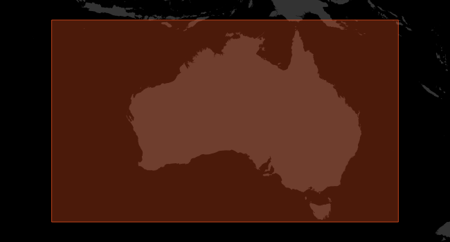
The spatial coverage of ABS Boundaries includes Australia’s land mass. The Bounding Box for this data is as follows:
North bounding latitude: -8˚
South bounding latitude: -45˚
East bounding longitude: 168˚
West bounding longitude: 96˚
The area covers the land mass of Australia, including offshore islands (Christmas Island, Cocos (Keeling) Islands, and Norfolk Island). The spatial domain is described by the polygon:
Spatial Reference System
GDA94
Horizontal Datum: The Geocentric Datum of Australia 1994 (GDA94) is the target horizontal datum.
Coordinate System: Geographic Coordinate System Geocentric Datum of Australia 1994 (GDA94).
GDA2020
Horizontal Datum: The Geocentric Datum of Australia 2020 (GDA2020) is the target horizontal datum.
Coordinate System: Geographic Coordinate System Geocentric Datum of Australia 2020 (GDA2020).
Data Model
The Main Structure layers are provided as a polygon feature datasets. Each layer contains geometry together with identifiers, names and hierarchical relationships that enable integration across the ASGS framework.
The Main Structures schema includes Mesh Blocks, SA1, SA2, SA3, SA4, GCCSA, State and Australia (aus) layers. These layers are linked through parent-child relationships that maintain the structure of the ASGS hierarchy.
Mesh Block, Statistical Area 1 and Statistical Area 2
![digraph G {
fontname="ROBOTO" fontsize="18pt"
node [fontname="ROBOTO" fontsize="15pt"]
edge [fontname="ROBOTO" fontsize="15pt"]
graph [pad="0.5", ranksep="0.75", nodesep="0.65"];
mb_2026 [shape=plain
label=<<TABLE BGCOLOR="#7EA6E0"
BORDER="1"
CELLBORDER="0"
style="rounded"
CELLSPACING="0"
CELLPADDING="5">
<TR>
<TD COLSPAN="2">mb_2026</TD>
</TR>
<TR>
<TD BGCOLOR="white" >PK</TD>
<TD BGCOLOR="white" ALIGN="LEFT" >mb_polygon_pid_2026: string (15) </TD>
</TR>
<TR>
<TD BGCOLOR="white" ></TD>
<TD BGCOLOR="white" ALIGN="LEFT" >date_created: date </TD>
</TR>
<TR>
<TD BGCOLOR="white" ></TD>
<TD BGCOLOR="white" ALIGN="LEFT" >mb_pid_2026: string (15) </TD>
</TR>
<TR>
<TD BGCOLOR="white" ></TD>
<TD BGCOLOR="white" ALIGN="LEFT" >mb_code_2026: string (11) </TD>
</TR>
<TR>
<TD BGCOLOR="white" ></TD>
<TD BGCOLOR="white" ALIGN="LEFT" >mb_category_2026: string (30) </TD>
</TR>
<TR>
<TD BGCOLOR="white" ></TD>
<TD BGCOLOR="white" ALIGN="LEFT" >change_flag_2026: string (1) </TD>
</TR>
<TR>
<TD BGCOLOR="white" ></TD>
<TD BGCOLOR="white" ALIGN="LEFT" >change_label_2026: string (11) </TD>
</TR>
<TR>
<TD BGCOLOR="white" >FK</TD>
<TD BGCOLOR="white" ALIGN="LEFT" >sa1_pid_2026: string (15) </TD>
</TR>
<TR>
<TD BGCOLOR="white" ></TD>
<TD BGCOLOR="white" ALIGN="LEFT" >sa1_code_2026: string (11) </TD>
</TR>
<TR>
<TD BGCOLOR="white" ></TD>
<TD BGCOLOR="white" ALIGN="LEFT" >sa2_code_2026: string (9) </TD>
</TR>
<TR>
<TD BGCOLOR="white" ></TD>
<TD BGCOLOR="white" ALIGN="LEFT" >sa2_name_2026: string (50) </TD>
</TR>
<TR>
<TD BGCOLOR="white" ></TD>
<TD BGCOLOR="white" ALIGN="LEFT" >sa3_code_2026: string (5) </TD>
</TR>
<TR>
<TD BGCOLOR="white" ></TD>
<TD BGCOLOR="white" ALIGN="LEFT" >sa3_name_2026: string (50) </TD>
</TR>
<TR>
<TD BGCOLOR="white" ></TD>
<TD BGCOLOR="white" ALIGN="LEFT" >sa4_code_2026: string (3) </TD>
</TR>
<TR>
<TD BGCOLOR="white" ></TD>
<TD BGCOLOR="white" ALIGN="LEFT" >sa4_name_2026: string (50) </TD>
</TR>
<TR>
<TD BGCOLOR="white" ></TD>
<TD BGCOLOR="white" ALIGN="LEFT" >gccsa_code_2026: string (5) </TD>
</TR>
<TR>
<TD BGCOLOR="white" ></TD>
<TD BGCOLOR="white" ALIGN="LEFT" >gccsa_name_2026: string (50) </TD>
</TR>
<TR>
<TD BGCOLOR="white" ></TD>
<TD BGCOLOR="white" ALIGN="LEFT" >state: string (3) </TD>
</TR>
<TR>
<TD BGCOLOR="white" ></TD>
<TD BGCOLOR="white" ALIGN="LEFT" >mb_area_sqkm_2026: real (9,2) </TD>
</TR>
<TR>
<TD BGCOLOR="white" ></TD>
<TD BGCOLOR="white" ALIGN="LEFT" >geometry: Polygon </TD>
</TR>
</TABLE>>];
sa1_2026 [shape=plain
label=<<TABLE BGCOLOR="#7EA6E0"
BORDER="1"
CELLBORDER="0"
style="rounded"
CELLSPACING="0"
CELLPADDING="5">
<TR>
<TD COLSPAN="2">sa1_2026</TD>
</TR>
<TR>
<TD BGCOLOR="white" >PK</TD>
<TD BGCOLOR="white" ALIGN="LEFT" >sa1_polygon_pid_2026: string (15) </TD>
</TR>
<TR>
<TD BGCOLOR="white" ></TD>
<TD BGCOLOR="white" ALIGN="LEFT" >date_created: date </TD>
</TR>
<TR>
<TD BGCOLOR="white" ></TD>
<TD BGCOLOR="white" ALIGN="LEFT" >sa1_pid_2026: string (15) </TD>
</TR>
<TR>
<TD BGCOLOR="white" ></TD>
<TD BGCOLOR="white" ALIGN="LEFT" >sa1_code_2026: string (11) </TD>
</TR>
<TR>
<TD BGCOLOR="white" ></TD>
<TD BGCOLOR="white" ALIGN="LEFT" >change_flag_2026: string (1) </TD>
</TR>
<TR>
<TD BGCOLOR="white" ></TD>
<TD BGCOLOR="white" ALIGN="LEFT" >change_label_2026: string (11) </TD>
</TR>
<TR>
<TD BGCOLOR="white" >FK</TD>
<TD BGCOLOR="white" ALIGN="LEFT" >sa2_pid_2026: string (13) </TD>
</TR>
<TR>
<TD BGCOLOR="white" ></TD>
<TD BGCOLOR="white" ALIGN="LEFT" >sa2_code_2026: string (9) </TD>
</TR>
<TR>
<TD BGCOLOR="white" ></TD>
<TD BGCOLOR="white" ALIGN="LEFT" >sa2_name_2026: string (50) </TD>
</TR>
<TR>
<TD BGCOLOR="white" ></TD>
<TD BGCOLOR="white" ALIGN="LEFT" >sa3_code_2026: string (5) </TD>
</TR>
<TR>
<TD BGCOLOR="white" ></TD>
<TD BGCOLOR="white" ALIGN="LEFT" >sa3_name_2026: string (50) </TD>
</TR>
<TR>
<TD BGCOLOR="white" ></TD>
<TD BGCOLOR="white" ALIGN="LEFT" >sa4_code_2026: string (3) </TD>
</TR>
<TR>
<TD BGCOLOR="white" ></TD>
<TD BGCOLOR="white" ALIGN="LEFT" >sa4_name_2026: string (50) </TD>
</TR>
<TR>
<TD BGCOLOR="white" ></TD>
<TD BGCOLOR="white" ALIGN="LEFT" >gccsa_code_2026: string (5) </TD>
</TR>
<TR>
<TD BGCOLOR="white" ></TD>
<TD BGCOLOR="white" ALIGN="LEFT" >gccsa_name_2026: string (50) </TD>
</TR>
<TR>
<TD BGCOLOR="white" ></TD>
<TD BGCOLOR="white" ALIGN="LEFT" >state: string (3) </TD>
</TR>
<TR>
<TD BGCOLOR="white" ></TD>
<TD BGCOLOR="white" ALIGN="LEFT" >sa1_area_sqkm_2026: real (9,2) </TD>
</TR>
<TR>
<TD BGCOLOR="white" ></TD>
<TD BGCOLOR="white" ALIGN="LEFT" >geometry: Polygon </TD>
</TR>
</TABLE>>];
sa2_2026 [shape=plain
label=<<TABLE BGCOLOR="#7EA6E0"
BORDER="1"
CELLBORDER="0"
style="rounded"
CELLSPACING="0"
CELLPADDING="5">
<TR>
<TD COLSPAN="2">sa2_2026</TD>
</TR>
<TR>
<TD BGCOLOR="white" >PK</TD>
<TD BGCOLOR="white" ALIGN="LEFT" >sa2_polygon_pid_2026: string (15) </TD>
</TR>
<TR>
<TD BGCOLOR="white" ></TD>
<TD BGCOLOR="white" ALIGN="LEFT" >date_created: date </TD>
</TR>
<TR>
<TD BGCOLOR="white" ></TD>
<TD BGCOLOR="white" ALIGN="LEFT" >sa2_pid_2026: string (13) </TD>
</TR>
<TR>
<TD BGCOLOR="white" ></TD>
<TD BGCOLOR="white" ALIGN="LEFT" >sa2_code_2026: string (9) </TD>
</TR>
<TR>
<TD BGCOLOR="white" ></TD>
<TD BGCOLOR="white" ALIGN="LEFT" >sa2_name_2026: string (50) </TD>
</TR>
<TR>
<TD BGCOLOR="white" ></TD>
<TD BGCOLOR="white" ALIGN="LEFT" >change_flag_2026: string (1) </TD>
</TR>
<TR>
<TD BGCOLOR="white" ></TD>
<TD BGCOLOR="white" ALIGN="LEFT" >change_label_2026: string (11) </TD>
</TR>
<TR>
<TD BGCOLOR="white" >FK</TD>
<TD BGCOLOR="white" ALIGN="LEFT" >sa3_pid_2026: string (9) </TD>
</TR>
<TR>
<TD BGCOLOR="white" ></TD>
<TD BGCOLOR="white" ALIGN="LEFT" >sa3_code_2026: string (5) </TD>
</TR>
<TR>
<TD BGCOLOR="white" ></TD>
<TD BGCOLOR="white" ALIGN="LEFT" >sa3_name_2026: string (50) </TD>
</TR>
<TR>
<TD BGCOLOR="white" ></TD>
<TD BGCOLOR="white" ALIGN="LEFT" >sa4_code_2026: string (3) </TD>
</TR>
<TR>
<TD BGCOLOR="white" ></TD>
<TD BGCOLOR="white" ALIGN="LEFT" >sa4_name_2026: string (50) </TD>
</TR>
<TR>
<TD BGCOLOR="white" ></TD>
<TD BGCOLOR="white" ALIGN="LEFT" >gccsa_code_2026: string (5) </TD>
</TR>
<TR>
<TD BGCOLOR="white" ></TD>
<TD BGCOLOR="white" ALIGN="LEFT" >gccsa_name_2026: string (50) </TD>
</TR>
<TR>
<TD BGCOLOR="white" ></TD>
<TD BGCOLOR="white" ALIGN="LEFT" >state: string (3) </TD>
</TR>
<TR>
<TD BGCOLOR="white" ></TD>
<TD BGCOLOR="white" ALIGN="LEFT" >sa2_area_sqkm_2026: real (9,2) </TD>
</TR>
<TR>
<TD BGCOLOR="white" ></TD>
<TD BGCOLOR="white" ALIGN="LEFT" >geometry: Polygon </TD>
</TR>
</TABLE>>];
}](_images/graphviz-6e8f91fa126efb81c038dadd0c7a271174d1bf1a.png)
Statistical Area 3, Statistical Area 4 and Greater Capital City Statistical Areas
![digraph G {
fontname="ROBOTO" fontsize="18pt"
node [fontname="ROBOTO" fontsize="15pt"]
edge [fontname="ROBOTO" fontsize="15pt"]
graph [pad="0.5", ranksep="0.75", nodesep="0.65"];
sa3_2026 [shape=plain
label=<<TABLE BGCOLOR="#7EA6E0"
BORDER="1"
CELLBORDER="0"
style="rounded"
CELLSPACING="0"
CELLPADDING="5">
<TR>
<TD COLSPAN="2">sa3_2026</TD>
</TR>
<TR>
<TD BGCOLOR="white" >PK</TD>
<TD BGCOLOR="white" ALIGN="LEFT" >sa3_polygon_pid_2026: string (15) </TD>
</TR>
<TR>
<TD BGCOLOR="white" ></TD>
<TD BGCOLOR="white" ALIGN="LEFT" >date_created: date </TD>
</TR>
<TR>
<TD BGCOLOR="white" ></TD>
<TD BGCOLOR="white" ALIGN="LEFT" >sa3_pid_2026: string (9) </TD>
</TR>
<TR>
<TD BGCOLOR="white" ></TD>
<TD BGCOLOR="white" ALIGN="LEFT" >sa3_code_2026: string (5) </TD>
</TR>
<TR>
<TD BGCOLOR="white" ></TD>
<TD BGCOLOR="white" ALIGN="LEFT" >sa3_name_2026: string (50) </TD>
</TR>
<TR>
<TD BGCOLOR="white" ></TD>
<TD BGCOLOR="white" ALIGN="LEFT" >change_flag_2026: string (1) </TD>
</TR>
<TR>
<TD BGCOLOR="white" ></TD>
<TD BGCOLOR="white" ALIGN="LEFT" >change_label_2026: string (11) </TD>
</TR>
<TR>
<TD BGCOLOR="white" >FK</TD>
<TD BGCOLOR="white" ALIGN="LEFT" >sa4_pid_2026: string (7) </TD>
</TR>
<TR>
<TD BGCOLOR="white" ></TD>
<TD BGCOLOR="white" ALIGN="LEFT" >sa4_code_2026: string (3) </TD>
</TR>
<TR>
<TD BGCOLOR="white" ></TD>
<TD BGCOLOR="white" ALIGN="LEFT" >sa4_name_2026: string (50) </TD>
</TR>
<TR>
<TD BGCOLOR="white" ></TD>
<TD BGCOLOR="white" ALIGN="LEFT" >gccsa_code_2026: string (5) </TD>
</TR>
<TR>
<TD BGCOLOR="white" ></TD>
<TD BGCOLOR="white" ALIGN="LEFT" >gccsa_name_2026: string (50) </TD>
</TR>
<TR>
<TD BGCOLOR="white" ></TD>
<TD BGCOLOR="white" ALIGN="LEFT" >state: string (3) </TD>
</TR>
<TR>
<TD BGCOLOR="white" ></TD>
<TD BGCOLOR="white" ALIGN="LEFT" >sa3_area_sqkm_2026: real (9,2) </TD>
</TR>
<TR>
<TD BGCOLOR="white" ></TD>
<TD BGCOLOR="white" ALIGN="LEFT" >geometry: Polygon </TD>
</TR>
</TABLE>>];
sa4_2026 [shape=plain
label=<<TABLE BGCOLOR="#7EA6E0"
BORDER="1"
CELLBORDER="0"
style="rounded"
CELLSPACING="0"
CELLPADDING="5">
<TR>
<TD COLSPAN="2">sa4_2026</TD>
</TR>
<TR>
<TD BGCOLOR="white" >PK</TD>
<TD BGCOLOR="white" ALIGN="LEFT" >sa4_polygon_pid_2026: string (15) </TD>
</TR>
<TR>
<TD BGCOLOR="white" ></TD>
<TD BGCOLOR="white" ALIGN="LEFT" >date_created: date </TD>
</TR>
<TR>
<TD BGCOLOR="white" ></TD>
<TD BGCOLOR="white" ALIGN="LEFT" >sa4_pid_2026: string (7) </TD>
</TR>
<TR>
<TD BGCOLOR="white" ></TD>
<TD BGCOLOR="white" ALIGN="LEFT" >sa4_code_2026: string (3) </TD>
</TR>
<TR>
<TD BGCOLOR="white" ></TD>
<TD BGCOLOR="white" ALIGN="LEFT" >sa4_name_2026: string (50) </TD>
</TR>
<TR>
<TD BGCOLOR="white" ></TD>
<TD BGCOLOR="white" ALIGN="LEFT" >change_flag_2026: string (1) </TD>
</TR>
<TR>
<TD BGCOLOR="white" ></TD>
<TD BGCOLOR="white" ALIGN="LEFT" >change_label_2026: string (11) </TD>
</TR>
<TR>
<TD BGCOLOR="white" >FK</TD>
<TD BGCOLOR="white" ALIGN="LEFT" >gccsa_pid_2026: string (9) </TD>
</TR>
<TR>
<TD BGCOLOR="white" ></TD>
<TD BGCOLOR="white" ALIGN="LEFT" >gccsa_code_2026: string (5) </TD>
</TR>
<TR>
<TD BGCOLOR="white" ></TD>
<TD BGCOLOR="white" ALIGN="LEFT" >gccsa_name_2026: string (50) </TD>
</TR>
<TR>
<TD BGCOLOR="white" ></TD>
<TD BGCOLOR="white" ALIGN="LEFT" >state: string (3) </TD>
</TR>
<TR>
<TD BGCOLOR="white" ></TD>
<TD BGCOLOR="white" ALIGN="LEFT" >sa4_area_sqkm_2026: real (9,2) </TD>
</TR>
<TR>
<TD BGCOLOR="white" ></TD>
<TD BGCOLOR="white" ALIGN="LEFT" >geometry: Polygon </TD>
</TR>
</TABLE>>];
gccsa_2026 [shape=plain
label=<<TABLE BGCOLOR="#7EA6E0"
BORDER="1"
CELLBORDER="0"
style="rounded"
CELLSPACING="0"
CELLPADDING="5">
<TR>
<TD COLSPAN="2">gccsa_2026</TD>
</TR>
<TR>
<TD BGCOLOR="white" >PK</TD>
<TD BGCOLOR="white" ALIGN="LEFT" >gccsa_polygon_pid_2026: string (15) </TD>
</TR>
<TR>
<TD BGCOLOR="white" ></TD>
<TD BGCOLOR="white" ALIGN="LEFT" >date_created: date </TD>
</TR>
<TR>
<TD BGCOLOR="white" ></TD>
<TD BGCOLOR="white" ALIGN="LEFT" >gccsa_pid_2026: string (9) </TD>
</TR>
<TR>
<TD BGCOLOR="white" ></TD>
<TD BGCOLOR="white" ALIGN="LEFT" >gccsa_code_2026: string (5) </TD>
</TR>
<TR>
<TD BGCOLOR="white" ></TD>
<TD BGCOLOR="white" ALIGN="LEFT" >gccsa_name_2026: string (50) </TD>
</TR>
<TR>
<TD BGCOLOR="white" ></TD>
<TD BGCOLOR="white" ALIGN="LEFT" >change_flag_2026: string (1) </TD>
</TR>
<TR>
<TD BGCOLOR="white" ></TD>
<TD BGCOLOR="white" ALIGN="LEFT" >change_label_2026: string (11) </TD>
</TR>
<TR>
<TD BGCOLOR="white" ></TD>
<TD BGCOLOR="white" ALIGN="LEFT" >state: string (3) </TD>
</TR>
<TR>
<TD BGCOLOR="white" ></TD>
<TD BGCOLOR="white" ALIGN="LEFT" >gccsa_area_sqkm_2026: real (9,2) </TD>
</TR>
<TR>
<TD BGCOLOR="white" ></TD>
<TD BGCOLOR="white" ALIGN="LEFT" >geometry: Polygon </TD>
</TR>
</TABLE>>];
}](_images/graphviz-dd19f8a4f31568d436b75ddd7e3c425bfa3c684f.png)
State and Australia
![digraph G {
fontname="ROBOTO" fontsize="18pt"
node [fontname="ROBOTO" fontsize="15pt"]
edge [fontname="ROBOTO" fontsize="15pt"]
graph [pad="0.5", ranksep="0.75", nodesep="0.65"];
state_2026 [shape=plain
label=<<TABLE BGCOLOR="#7EA6E0"
BORDER="1"
CELLBORDER="0"
style="rounded"
CELLSPACING="0"
CELLPADDING="5">
<TR>
<TD COLSPAN="2">state_2026</TD>
</TR>
<TR>
<TD BGCOLOR="white" >PK</TD>
<TD BGCOLOR="white" ALIGN="LEFT" >state_polygon_pid_2026: string (15) </TD>
</TR>
<TR>
<TD BGCOLOR="white" ></TD>
<TD BGCOLOR="white" ALIGN="LEFT" >date_created: date </TD>
</TR>
<TR>
<TD BGCOLOR="white" ></TD>
<TD BGCOLOR="white" ALIGN="LEFT" >state_pid_2026: string (5) </TD>
</TR>
<TR>
<TD BGCOLOR="white" ></TD>
<TD BGCOLOR="white" ALIGN="LEFT" >state_code_2026: string (1) </TD>
</TR>
<TR>
<TD BGCOLOR="white" ></TD>
<TD BGCOLOR="white" ALIGN="LEFT" >state_name_2026: string (50) </TD>
</TR>
<TR>
<TD BGCOLOR="white" ></TD>
<TD BGCOLOR="white" ALIGN="LEFT" >change_flag_2026: string (1) </TD>
</TR>
<TR>
<TD BGCOLOR="white" ></TD>
<TD BGCOLOR="white" ALIGN="LEFT" >change_label_2026: string (11) </TD>
</TR>
<TR>
<TD BGCOLOR="white" >FK</TD>
<TD BGCOLOR="white" ALIGN="LEFT" >aus_pid_2026: string (7) </TD>
</TR>
<TR>
<TD BGCOLOR="white" ></TD>
<TD BGCOLOR="white" ALIGN="LEFT" >aus_code_2026: string (3) </TD>
</TR>
<TR>
<TD BGCOLOR="white" ></TD>
<TD BGCOLOR="white" ALIGN="LEFT" >aus_name_2026: string (50) </TD>
</TR>
<TR>
<TD BGCOLOR="white" ></TD>
<TD BGCOLOR="white" ALIGN="LEFT" >state_area_sqkm_2026: real (9,2) </TD>
</TR>
<TR>
<TD BGCOLOR="white" ></TD>
<TD BGCOLOR="white" ALIGN="LEFT" >geometry: Polygon </TD>
</TR>
</TABLE>>];
aus_2026 [shape=plain
label=<<TABLE BGCOLOR="#7EA6E0"
BORDER="1"
CELLBORDER="0"
style="rounded"
CELLSPACING="0"
CELLPADDING="5">
<TR>
<TD COLSPAN="2">aus_2026</TD>
</TR>
<TR>
<TD BGCOLOR="white" >PK</TD>
<TD BGCOLOR="white" ALIGN="LEFT" >aus_polygon_pid_2026: string (15) </TD>
</TR>
<TR>
<TD BGCOLOR="white" ></TD>
<TD BGCOLOR="white" ALIGN="LEFT" >date_created: date </TD>
</TR>
<TR>
<TD BGCOLOR="white" ></TD>
<TD BGCOLOR="white" ALIGN="LEFT" >aus_pid_2026: string (7) </TD>
</TR>
<TR>
<TD BGCOLOR="white" ></TD>
<TD BGCOLOR="white" ALIGN="LEFT" >aus_code_2026: string (3) </TD>
</TR>
<TR>
<TD BGCOLOR="white" ></TD>
<TD BGCOLOR="white" ALIGN="LEFT" >aus_name_2026: string (50) </TD>
</TR>
<TR>
<TD BGCOLOR="white" ></TD>
<TD BGCOLOR="white" ALIGN="LEFT" >change_flag_2026: string (1) </TD>
</TR>
<TR>
<TD BGCOLOR="white" ></TD>
<TD BGCOLOR="white" ALIGN="LEFT" >change_label_2026: string (11) </TD>
</TR>
<TR>
<TD BGCOLOR="white" ></TD>
<TD BGCOLOR="white" ALIGN="LEFT" >aus_area_sqkm_2026: real (9,2) </TD>
</TR>
<TR>
<TD BGCOLOR="white" ></TD>
<TD BGCOLOR="white" ALIGN="LEFT" >geometry: Polygon </TD>
</TR>
</TABLE>>];
}](_images/graphviz-d3768a943686f5ccd276e2abe831ceb42f48c4cc.png)
Data Dictionary
mb_2026 table¶ Name
Data Type
Description
Primary Key
Mandatory Field
10 Character Alias
mb_polygon_pid_2026
string(15)
Unique persistent identifier for the Mesh Block polygon.
Yes
Yes
MB_PLY_26
date_created
date
The date the record is first introduced to the Geoscape product.
No
Yes
DT_CREATE
mb_pid_2026
string(15)
Persistent identifier for the Mesh Block feature.
No
Yes
MB_PID_26
mb_code_2026
string(11)
The Mesh Block code.
No
Yes
MB_CODE_26
mb_category_2026
string(30)
The category of land use allocated to the Mesh Block.
No
Yes
MB_CAT_26
change_flag_2026
string(1)
A flag indicating whether the Mesh Block is new or has had a code or name change from the previous ASGS.
No
Yes
CHN_FLG_26
change_label_2026
string(11)
A flag indicating whether the Mesh Block is new or has had a code or name change from the previous ASGS.
No
Yes
CHN_LBL_26
sa1_pid_2026
string(15)
The persistent identifier from the sa1_2021 table.
No
Yes
S1_PID_26
sa1_code_2026
string(11)
The SA1 code.
No
Yes
S1_CODE_26
sa2_code_2026
string(9)
The SA2 code.
No
Yes
S2_CODE_26
sa2_name_2026
string(50)
The SA2 name.
No
Yes
S2_NAME_26
sa3_code_2026
string(5)
The SA3 code.
No
Yes
S3_CODE_26
sa3_name_2026
string(50)
The SA3 name.
No
Yes
S3_NAME_26
sa4_code_2026
string(3)
The SA4 code.
No
Yes
S4_CODE_26
sa4_name_2026
string(50)
The SA4 name.
No
Yes
S4_NAME_26
gccsa_code_2026
string(5)
The GCCSA code.
No
Yes
GC_CODE_26
gccsa_name_2026
string(50)
The GCCSA name.
No
Yes
GC_NAME_26
state
string(3)
The abbreviated name of the State or Territory.
No
No
STATE
mb_area_sqkm_2026
real(9,2)
The area in square kilometers calculated by the ABS using the Albers projection. Polygons with the same mb code will each be assigned the total area relating to that Mesh Block.
No
Yes
MB_AR_SQKM
geometry
Polygon
Polygon Geometry. Aspatial records are also provided.
No
No
GEOMETRY
sa1_2026 table¶ Name
Data Type
Description
Primary Key
Mandatory Field
10 Character Alias
sa1_polygon_pid_2026
string(15)
Unique persistent identifier for the SA1 polygon.
Yes
Yes
S1_PLY_26
date_created
date
The date the record is first introduced to the Geoscape product.
No
Yes
DT_CREATE
sa1_pid_2026
string(15)
Persistent identifier for the SA1 feature.
No
Yes
S1_PID_26
sa1_code_2026
string(11)
The SA1 code.
No
Yes
S1_CODE_26
change_flag_2026
string(1)
A flag indicating whether the SA1 is new or has had a code or name change from the previous ASGS.
No
Yes
CHN_FLG_26
change_label_2026
string(11)
A flag indicating whether the SA1 is new or has had a code or name change from the previous ASGS.
No
Yes
CHN_LBL_26
sa2_pid_2026
string(13)
The persistent identifier from the sa2_2026 table.
No
Yes
S2_PID_26
sa2_code_2026
string(9)
The SA2 code.
No
Yes
S2_CODE_26
sa2_name_2026
string(50)
The SA2 name.
No
Yes
S2_NAME_26
sa3_code_2026
string(5)
The SA3 code.
No
Yes
S3_CODE_26
sa3_name_2026
string(50)
The SA3 name.
No
Yes
S3_NAME_26
sa4_code_2026
string(3)
The SA4 code.
No
Yes
S4_CODE_26
sa4_name_2026
string(50)
The SA4 name.
No
Yes
S4_NAME_26
gccsa_code_2026
string(5)
The GCCSA code.
No
Yes
GC_CODE_26
gccsa_name_2026
string(50)
The GCCSA name.
No
Yes
GC_NAME_26
state
string(15)
The abbreviated name of the State or Territory.
No
No
STATE
sa1_area_sqkm_2026
real(9,2)
The area in square kilometers calculated by the ABS using the Albers projection. Polygons with the same sa1 code will each be assigned the total area relating to that SA1.
No
Yes
S1_AR_SQKM
geometry
Polygon
Polygon Geometry. Aspatial records are also provided.
No
No
GEOMETRY
sa2_2026 table¶ Name
Data Type
Description
Primary Key
Mandatory Field
10 Character Alias
sa2_polygon_pid_2026
string(15)
Unique persistent identifier for the SA2 polygon.
Yes
Yes
S2_PLY_26
date_created
date
The date the record is first introduced to the Geoscape product.
No
Yes
DT_CREATE
sa2_pid_2026
string(13)
Persistent identifier for the SA2 feature.
No
Yes
S2_PID_26
sa2_code_2026
string(9)
The SA2 code.
No
Yes
S2_CODE_26
sa2_name_2026
string(50)
The SA2 name.
No
Yes
S2_NAME_26
change_flag_2026
string(1)
A flag indicating whether the SA2 is new or has had a code or name change from the previous ASGS.
No
Yes
CHN_FLG_26
change_label_2026
string(11)
A flag indicating whether the SA2 is new or has had a code or name change from the previous ASGS.
No
Yes
CHN_LBL_26
sa3_pid_2026
string(9)
The persistent identifier from the sa3_2026 table.
No
Yes
S3_PID_26
sa3_code_2026
string(5)
The SA3 code.
No
Yes
S3_CODE_26
sa3_name_2026
string(50)
The SA3 name.
No
Yes
S3_NAME_26
sa4_code_2026
string(3)
The SA34 code.
No
Yes
S4_CODE_26
sa4_name_2026
string(50)
The SA4 name.
No
Yes
S4_NAME_26
gccsa_code_2026
string(5)
The GCCSA code.
No
Yes
GC_CODE_26
gccsa_name_2026
string(50)
The GCCSA name.
No
Yes
GC_NAME_26
state
string(3)
The abbreviated name of the State or Territory.
No
No
STATE
sa2_area_sqkm_2026
real(9,2)
The area in square kilometers calculated by the ABS using the Albers projection. Polygons with the same sa2 code will each be assigned the total area relating to that SA2.
No
Yes
S2_AR_SQKM
geometry
Polygon
Polygon Geometry. Aspatial records are also provided.
No
No
GEOMETRY
sa3_2026 table¶ Name
Data Type
Description
Primary Key
Mandatory Field
10 Character Alias
sa3_polygon_pid_2026
string(15)
Unique persistent identifier for the SA3 polygon.
Yes
Yes
S3_PLY_26
date_created
date
The date the record is first introduced to the Geoscape product.
No
Yes
DT_CREATE
sa3_pid_2026
string(9)
Persistent identifier for the SA3 feature.
No
Yes
S3_PID_26
sa3_code_2026
string(5)
The SA3 code.
No
Yes
S3_CODE_26
sa3_name_2026
string(50)
The SA3 name.
No
Yes
S3_NAME_26
change_flag_2026
string(1)
A flag indicating whether the SA3 is new or has had a code or name change from the previous ASGS.
No
Yes
CHN_FLG_26
change_label_2026
string(11)
A flag indicating whether the SA3 is new or has had a code or name change from the previous ASGS.
No
Yes
CHN_LBL_26
sa4_pid_2026
string(7)
The persistent identifier from the sa4_2026 table.
No
Yes
S4_PID_26
sa4_code_2026
string(3)
The SA4 code.
No
Yes
S4_CODE_26
sa4_name_2026
string(50)
The SA4 name.
No
Yes
S4_NAME_26
gccsa_code_2026
string(5)
The GCCSA code.
No
Yes
GC_CODE_26
gccsa_name_2026
string(50)
The GCCSA name.
No
Yes
GC_NAME_26
state
string(3)
The abbreviated name of the State or Territory.
No
No
STATE
sa3_area_sqkm_2026
real(9,2)
The area in square kilometers calculated by the ABS using the Albers projection. Polygons with the same sa3 code will each be assigned the total area relating to that SA3.
No
Yes
S3_AR_SQKM
geometry
Polygon
Polygon Geometry. Aspatial records are also provided.
No
No
GEOMETRY
sa4_2026 table¶ Name
Data Type
Description
Primary Key
Mandatory Field
10 Character Alias
sa4_polygon_pid_2026
string(15)
Unique persistent identifier for the SA4 polygon.
Yes
Yes
S4_PLY_26
date_created
date
The date the record is first introduced to the Geoscape product.
No
Yes
DT_CREATE
sa4_pid_2026
string(7)
Persistent identifier for the SA4 feature.
No
Yes
S4_PID_26
sa4_code_2026
string(3)
The SA4 code.
No
Yes
S4_CODE_26
sa4_name_2026
string(50)
The SA4 name.
No
Yes
S4_NAME_26
change_flag_2026
string(1)
A flag indicating whether the SA4 is new or has had a code or name change from the previous ASGS.
No
Yes
CHN_FLG_26
change_label_2026
string(11)
A flag indicating whether the SA4 is new or has had a code or name change from the previous ASGS.
No
Yes
CHN_LBL_26
gccsa_pid_2026
string(9)
The persistent identifier from the gccsa_2026 table.
No
Yes
GC_PID_26
gccsa_code_2026
string(5)
The GCCSA code.
No
Yes
GC_CODE_26
gccsa_name_2026
string(50)
The GCCSA name.
No
Yes
GC_NAME_26
state
string(3)
The abbreviated name of the State or Territory.
No
No
STATE
sa4_area_sqkm_2026
real(9,2)
The area in square kilometers calculated by the ABS using the Albers projection. Polygons with the same sa3 code will each be assigned the total area relating to that SA3.
No
Yes
S4_AR_SQKM
geometry
Polygon
Polygon Geometry. Aspatial records are also provided.
No
No
GEOMETRY
gccsa_2026 table¶ Name
Data Type
Description
Primary Key
Mandatory Field
10 Character Alias
gccsa_polygon_pid_2026
string(15)
Unique persistent identifier for the GCCSA polygon.
Yes
Yes
GC_PLY_26
date_created
date
The date the record is first introduced to the Geoscape product.
No
Yes
DT_CREATE
gccsa_pid_2026
string(9)
Persistent identifier for the GCCSA feature.
No
Yes
GC_PID_26
gccsa_code_2026
string(5)
The GCCSA code.
No
Yes
GC_CODE_26
gccsa_name_2026
string(50)
The GCCSA name.
No
Yes
GC_NAME_26
change_flag_2026
string(1)
A flag indicating whether the GCCSA is new or has had a code or name change from the previous ASGS.
No
Yes
CHN_FLG_26
change_label_2026
string(11)
A flag indicating whether the SA4 is new or has had a code or name change from the previous ASGS.
No
Yes
CHN_LBL_26
state
string(3)
Theabbreviated name of the State or Territory.
No
No
STATE
gccsa_area_sqkm_2026
real(9,2)
The area in square kilometers calculated by the ABS using the Albers projection. Polygons with the same gccsa code will each be assigned the total area relating to that GCCSA.
GC_AR_SQKM
geometry
Polygon
Polygon Geometry. Aspatial records are also provided.
No
No
GEOMETRY
state_2026 table¶ Name
Data Type
Description
Primary Key
Mandatory Field
10 Character Alias
state_polygon_pid_2026
string(15)
Unique persistent identifier for the state polygon.
Yes
Yes
ST_PLY_26
date_created
date
The date the record is first introduced to the Geoscape product.
No
Yes
DT_CREATE
state_pid_2026
string(5)
Persistent identifier for the state feature.
No
Yes
ST_PID_26
state_code_2026
string(1)
The state code.
No
Yes
ST_CODE_26
state_name_2026
string(50)
The state name.
No
Yes
ST_NAME_26
change_flag_2026
string(1)
A flag indicating whether the state is new or has had a code or name change from the previous ASGS.
No
Yes
CHN_FLG_26
change_label_2026
string(11)
A flag indicating whether the state is new or has had a code or name change from the previous ASGS.
No
Yes
CHN_LBL_26
aus_pid_2026
string(7)
The persistent identifier from the aus_2026 table.
No
Yes
AU_PID_26
aus_code_2026
string(3)
The aus code.
No
Yes
AU_CODE_26
aus_name_2026
string(50)
The aus name.
No
Yes
AU_NAME_26
state_area_sqkm_2026
real(9,2)
The area in square kilometers calculated by the ABS using the Albers projection. Polygons with the same state code will each be assigned the total area relating to that state.
No
Yes
ST_AR_SQKM
geometry
Polygon
Polygon Geometry. Aspatial records are also provided.
No
No
GEOMETRY
aus_2026 table¶ Name
Data Type
Description
Primary Key
Mandatory Field
10 Character Alias
aus_polygon_pid_2026
string(15)
Unique persistent identifier for the state polygon.
Yes
Yes
AU_PLY_26
date_created
date
The date the record is first introduced to the Geoscape product.
No
Yes
DT_CREATE
aus_pid_2026
string(7)
Persistent identifier for the aus feature.
No
Yes
AU_PID_26
aus_code_2026
string(3)
The aus code.
No
Yes
AU_CODE_26
aus_name_2026
string(50)
The aus name.
No
Yes
AU_NAME_26
change_flag_2026
string(1)
A flag indicating whether the aus record is new or has had a code or name change from the previous ASGS.
No
Yes
CHN_FLG_26
change_label_2026
string(11)
A flag indicating whether the aus record is new or has had a code or name change from the previous ASGS.
No
Yes
CHN_LBL_26
aus_area_sqkm_2026
real(9,2)
The area in square kilometers calculated by the ABS using the Albers projection. Polygons with the same aus code will each be assigned the total area relating to that aus.
No
Yes
AU_AR_SQKM
geometry
Polygon
Polygon Geometry. Aspatial records are also provided.
No
No
GEOMETRY
Data Quality
Positional Accuracy
Positional accuracy is an assessment of the closeness of the location of the spatial objects in relation to their true positions on the earth’s surface.
The positional accuracy includes:
a horizontal accuracy assessment
a vertical accuracy assessment
The horizontal and vertical positional accuracy are the assessed accuracy after all transformations have been carried out.
The ABS data has accuracy from +/- 25 metres in Urban Areas to +/- 50 metres in Rural Areas. No “shift” of data as a means of “cartographic enhancement” to facilitate presentation has been employed for any real-world feature.
Note
The accuracy of geometric representation is given by the difference between the position of the geometric representation of an object and its absolute position, as measured with respect to the geodetic network.
Coordinates Referencing the GDA2020 Datum
Spatial features referencing the GDA2020 datum are produced using a coordinate transformation from the GDA94 datum using the following parameters.
shift_x = 0.06155,
shift_y = -0.01087,
shift_z = -0.04019,
rotate_x = -0.0394924,
rotate_y = -0.0327221,
rotate_z = -0.0328979,
scale_adjust = -0.009994
Attribute accuracy
Attribute accuracy is an assessment of the reliability of values assigned to features in the dataset in relation to their true ‘real world’ values.
Key attributes (name and the unique identifier) have a high degree of accuracy in the order of 99.09%. Other attributes derived from the processing of supplied data may have a lower degree of accuracy but less than previously released data. All attribute accuracies are dependent on the data accuracy supplied to Geoscape Australia.
For this product, feature and attribute accuracy is a measure of the degree to which the features and attribute values of spatial objects agree with the information on the source material. The allowable error in attribute accuracy was previously up to 5%.
A precise attribute accuracy assessment may not always be possible. In these cases an intuitive estimate of the expected attribute accuracy or the likely maximum error based on previous experience is acceptable.
Logical consistency
Logical consistency is a measure of the degree to which data complies with the technical specification. The allowable error in logical consistency previously ranged from 3% to 5%. The test procedures are a mixture of software scripts and onscreen, visual checks.
The data structure has been tested for conformance with the data model. The following have been tested and confirmed to conform:
File names
Attribute names
Attribute lengths
Attribute types
Attribute domains
Attribute order in file
Object type
Compulsory attributes populated
Topological consistency
ABS Boundary geometries are validated to ensure polygons are a valid representation and free of self-intersection.
Polygons conform to the following specification:
OGC Simple Feature Access Specification v1.2.1 [Section - 6.1.11.1]
ABS Boundaries has been processed to assure all polygons are stored as single part features to improve compatibility with a range of software applications. Due to this there can be a duplication of PIDs within a layer where there are multiple polygons represented by a single PID.
Completeness
Completeness is an assessment of the extent and range of the dataset in regard to completeness of coverage, completeness of classification and completeness of verification.
Attribute completeness
All attributes for each object are populated according to the data model, noting that some attributes are not mandatory.
Temporal accuracy for each layer is applicable to its most current release.
Quality scope
Polygon geometry accuracy and attribute accuracy for all included areas.
Delivery Format
Components
ABS ASGS 2026 Main Structure is a vector data product and is made available for each State or Territory in the formats listed below. The Australian Government releases ABS Boundaries on data.gov.au in ESRI Shape and MapInfo TAB formats.
Format |
National |
State/Territory |
|---|---|---|
File Geodatabase |
Yes |
Yes |
GeoJSON |
Yes |
Yes |
ESRI Shapefile |
Yes |
Yes |
MapInfo TAB |
Yes |
Yes |
Geopackage |
Yes |
Yes |
File Geodatabase
GeoJSON
Note
The GeoJSON specification states that the coordinate reference system for all GeoJSON coordinates is:
“a geographic coordinate reference system, using the World Geodetic System 1984 (WGS 84) datum, with longitude and latitude units of decimal degrees”
Buildings will be provided with coordinates using the datum selected for download (GDA94/GDA2020) with longitude and latitude units of decimal degrees.